
There is nothing there, yet it is still a sculpture.
-Michael Heizer

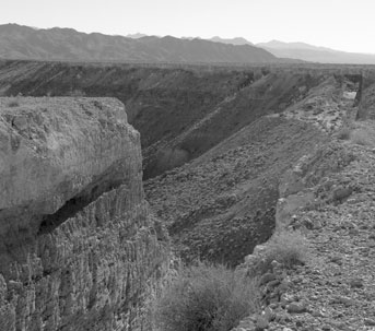
DOUBLE NEGATIVE, FROM THE EDGE OF THE WORK
Double Negative is Michael Heizer's first prominent earthwork. It consists of two trenches cut into the eastern edge of the Mormon Mesa, northwest of Overton, Nevada in 1969-70.
The trenches (seen as dark lines or shadows below in the Google Maps satellite imagery) line up across a large gap formed by the natural shape of the mesa edge. Including this open area across the gap, the trenches together measure 1,500 feet long, 50 feet deep, and 30 feet wide (457 meters long, 15.2 meters deep, 9.1 meters wide). A reported 240,000 tons (218,000 tonnes) of rock, mostly rhyolite and sandstone, was displaced in the construction of the trenches.
Double Negative was among the first "earthworks" -- artworks that use as their canvas or medium the earth itself. In keeping with the mission of modern art, Double Negative blurs the distinction between sculpture ("art") and normal objects such as rocks ("not art"), and encourage viewers to consider how the earth relates to art. The sheer size of Double Negative also invites contemplation of the scale of art, and the relation of the viewer the earth and to art itself. How does art change when it can't fit in a museum? How does one observe an artwork that's a quarter-mile long?
Double Negative, though a notable piece of art, is essentially no more than a big trench (and even then, not a complete trench, as it crosses empty space). In that, it consists more of what was than what currently is. Constructing Double Negative was an act of "construction" only inasmuch as something was taken away, and that this removal constituted a creative act. In that the artwork is itself negative space (and when it crosses empty space, it is doubly negative space, as the title suggests), it begs meditation on the principle of art as creation, when Heizer has not in fact added but subtracted.
Double Negative belongs to The Museum of Contemporary Art, Los Angeles, through the gift of Virginia Dwan.

Visiting Double Negative
Double Negative is located in a rather remote area of the Nevada desert, but it can be visited relatively easily from Las Vegas. The journey requires travel on unpaved, rocky roads, so a vehicle with high clearance and good tires is highly recommended.
Before You Go
Reliable directions to Double Negative can be hard to come by, even from locals in Overton or via Google Maps. It can be very easy to become disoriented on the mesa, particularly given the numerous unpaved roads, and a cell phone signal may not be available. We therefore encourage you to either print these directions or pull them up on your cell phone while in Overton, to ensure that they will be available offline.
Some walking in rocky, sandy terrain is required, so you should be prepared for exposure to desert temperatures, which in the summer can run up to 120 degrees. We recommend that you bring extra water and wear sturdy walking shoes.
Using the directions below, Double Negative is approximately 75 miles from the Las Vegas Strip. Though the highway travel proceeds quickly, you will want to proceed slowly through town and on the dirt roads. Assuming no traffic, we estimate approximately 90 minutes for the journey, each way.
Getting to Double Negative
The mostly unpaved road to Double Negative is most easily traveled from Overton. Overton can be reached from Las Vegas by traveling North on I-15 for approximately 55 miles and taking Exit 93 - NV Hwy 169 - towards Logandale/Overton. Overton is approximately 11 miles south-east of I-15 on NV Hwy 169.

In town, NV Hwy 169 becomes Moapa Valley Blvd. Continue to follow NV-169/Moapa Valley Blvd. through Logandale and Overton -- including as it curves. As you hit the center of Overton, you'll notice some government buildings -- as well as a tank -- on your left, and a post office on your right. This means your left turn is close.
Just past the Maverik Gas Station, make a sharp left (traveling North) onto Cooper Street (listed on Google Maps as Cooper Avenue). (If you pass through downtown Overton and see the McDonald's, you've gone too far on Moapa Valley Blvd. -- turn around and take the right fork, Cooper Street, where the road splits.)
Follow Cooper Street through a residential neighborhood, up a small hill, and out of town until you hit the Overton Airport (marked on the map above). Near the airport, Cooper veers right and becomes Mormon Mesa Road. (If you took a left onto Airport Rd., make an immediate right just before the Airport to hit Mormon Mesa Road.)
Continue on Mormon Mesa Road towards the large mesa ahead of you. This is the Mormon Mesa, or Virgin River Mesa. The road is only partially paved; most of the rest of the way it is dirt/graded gravel. Climb on Mormon Mesa Road up to the top of the mesa.
As you come to the top of the mesa (marked "Mesa Edge" on the map), you will pass a cattle guard. Continue east across the mesa, a bit more than 2.7 miles Do NOT leave the mesa. If you are descending down the east edge of the Mesa, you have gone too far.
Just before you come across a second cattle guard (marked "Cattle Guard" on the map) at the east edge of the mesa, there will be a less-traveled road that extends along the rim of the mesa. Note your mileage, turn left onto this rim road, and follow it north for 1.4 miles.
PROCEED SLOWLY AND BE ALERT! Without care, you can drive off the edge of the mesa, and we think that the tumble into the valley below will strongly decrease your chances of seeing the artwork.
The last time we visited, we found travel on the mesa quite confusing, thanks to a large number of additional paths carved by various vehicles. Google Maps satellite view was very helpful in remaining on the most direct path to the artwork; for your convenience, the map above has the location of the artwork pinned and will expand to a full map. The road nearest the mesa's East Rim -- one of many marked "Carp Elgin Road" on Google Maps -- takes you very near to the site, which is visible in the satellite imagery as a marked shadow (see above).
If your phone is not receiving a GPS signal, you will have to do your best to follow the road north and try to stay on the road that is close to the rim of the mesa -- though note that, at least for the first few times, you need not follow precisely every contour of the mesa and can try to take a more direct route.
After 1.4 miles on the rim road (via a relatively direct route), park your vehicle. Walk east towards the rim of the mesa until you find the earthwork. You should be within approximately 50 yards of the earthwork. We estimate that, even using an extremely circuitous route following nearly every contour of the mesa edge -- which, again, is not not necessary -- you should hit the artwork at approximately 2.6-2.7 miles.
Part of the beauty of earthworks lies in their natural surroundings. Please do not disturb the desert ecosystem found around Double Negative. The surrounding area is public land belonging to the Bureau of Reclamation or the Bureau of Land Management. Collecting or disturbing plants, fossils, or artifacts on this land is prohibited.